Category:RAF Deenethorpe
Jump to navigation
Jump to search
| Object location | | View all coordinates using: OpenStreetMap |
|---|
RAF airbase in England, UK  | |||||
| Upload media | |||||
| Instance of |
| ||||
|---|---|---|---|---|---|
| Location | England | ||||
| Operator | |||||
| Inception |
| ||||
| Dissolved, abolished or demolished date |
| ||||
| ICAO airport code |
| ||||
 | |||||
Subcategories
This category has only the following subcategory.
Media in category "RAF Deenethorpe"
The following 18 files are in this category, out of 18 total.
-
 Deenthorpe-28-may-1947.jpg 600 × 821; 128 KB
-
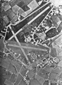 Deenthorpe-28-may-1947.png 600 × 821; 573 KB
-
 401bg-deenthorpe.jpg 1,800 × 1,154; 143 KB
-
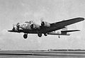 614th Bombardment Squadron - B-17 Flying Fortress.jpg 2,000 × 1,366; 303 KB
-
 RAF Deenethorpe - 401st Bombardment Group B-17G 44-8258.jpg 1,314 × 864; 215 KB
-
 RAF Deenethorpe - 401st Bombardment Group B-17G Fancy Nancy IV.jpg 1,368 × 946; 282 KB
-
 RAF Deenethorpe - 401st Bombardment Group B-17G Lady Jane.jpg 1,304 × 1,014; 236 KB
-
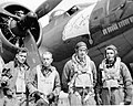
 RAF Deenethorpe - 401st Bombardment Group Bomber Crew 2.jpg 1,343 × 1,024; 216 KB
-
 RAF Deenethorpe - 401st Bombardment Group Bomber Crew.jpg 1,390 × 941; 240 KB
-
 RAF Deenethorpe - 401st Bombardment Group Marlene Dietrich.jpg 1,297 × 1,020; 244 KB
-
 RAF Deenethorpe - 401st Bombardment Group Operations Room.jpg 1,277 × 1,021; 283 KB
-
 RAF Deenethorpe - Control Tower.jpg 867 × 695; 132 KB
-
-
 RAF Deenethorpe - geograph.org.uk - 2166255.jpg 3,456 × 2,304; 2.68 MB
-
 RAF Deenethorpe - geograph.org.uk - 2166261.jpg 3,456 × 2,304; 3.32 MB
-
 RAF Deenethorpe - geograph.org.uk - 2166267.jpg 3,456 × 2,304; 3.49 MB
-
 RAF Deenethorpe - geograph.org.uk - 2166271.jpg 3,456 × 2,304; 3.14 MB
-


